Why Nearby Places Look Far Apart on a Map
Map scale can make nearby farms and villages look far apart. Learn to compare maps accurately, even when a printout or screen has been resized.
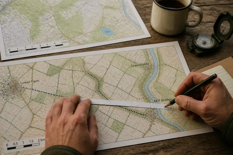
Why do the same village and footbridge look far apart on one map and close together on another? Map scale changes how much ground fits into the space on the page or screen, so check it before comparing the gap. If you need the walking distance, trace the route; if you need the direct separation, measure between the same points in a straight line.
Read the map scale
Look near the map edge for a scale bar, a written scale or a ratio such as 1:25,000. At that ratio, one unit measured on the map represents 25,000 of the same units on the ground. A scale bar shows the same relationship as a labelled line.
A larger-scale map, such as 1:10,000, shows a smaller area with more detail than a 1:50,000 map. Do not compare ruler readings across maps until each reading has been converted using its own scale.
Check resizing first
A printed map may have been enlarged or reduced, and an image may be resized on screen. In either case, the original written ratio might no longer match the displayed map. A scale bar printed as part of the same image usually resizes with it, so it can still be used if it remains legible and has not been cropped or altered separately.
For a printout, compare the bar’s current length with its labelled ground distance rather than assuming the original page size. For a digital map, use a scale bar that updates as you zoom. If the bar is missing, distorted or fixed while the map changes, do not rely on a ruler against the display; open the map at its intended size or use a dependable digital measuring tool.
Measure a route correctly
To estimate a winding route on paper, use a narrow strip of paper and the map’s scale bar. Put the strip’s edge on the route, mark the starting point, then turn the strip at each bend and add a small mark where the path changes direction. Move the strip along the route without leaving gaps, and mark the finish. The distance between the start and finish marks is the route length on the map.
Now align the strip’s marked length with the scale bar: place the start mark at the bar’s zero point and compare the finish mark with the bar’s labelled divisions. If the finish falls between divisions, estimate the fraction of that interval. For a longer route, the strip may extend beyond the bar; measure it in sections, recording each section’s ground distance and adding them. This method is like using a flexible ribbon to follow a winding lane, rather than stretching a rigid ruler across its bends.
Say you are tracing a footpath from a farm to a bridge on a printout. You mark each bend on the paper strip, align the first mark with zero on the bar, and see that the finish lies just beyond the bar’s 2-kilometre label. You would record an estimate slightly over 2 kilometres, not an exact figure; if the strip had to be measured in two sections, add the two bar-based estimates instead.
For the straight-line distance, draw or imagine a direct line between the same start and finish points, then measure that line against the scale bar. Do not use the winding strip result for this: it follows the route, so it will generally be longer than the direct line.
Compare the same features
Use consistent points on each map, such as the centres of two settlement symbols, rather than measuring from the edge of one symbol to the centre of another. Symbols can be larger than the features they represent, so treat close measurements as estimates.
Check the legend before comparing lines. A line may represent a road, footpath, stream or field boundary; similar-looking marks on different maps need not show the same feature. Smaller-scale maps may omit narrow lanes, minor streams or individual boundaries, so a missing mark is not proof that the feature is absent.
Check the map’s date
Maps at the same scale can show different versions of the countryside. A lane may have changed, a stream may have been diverted, or field boundaries may have been revised. Look for a publication date, revision note or source information before treating differences as a matter of scale alone.
If you are planning a walk, check a current local map and confirm access with the relevant land manager where needed. A mapped path does not, on its own, confirm that the route is open or passable now.
Questions about map scale?
Does a larger-scale map show more detail?
Usually: it represents a smaller area, so features can be shown more prominently. Check the ratio, not the apparent size of the map on your screen.
Can a resized printout still be measured?
Yes, if a scale bar is visible and has resized with the map image. Compare your measurement with that bar; do not apply the original ratio blindly to a printout that may have been enlarged or reduced.
How do I measure a straight-line distance?
Measure directly between the chosen points with a ruler or draw a straight line between them. Compare that map length with the scale bar, rather than following bends in a road or path.
Is walking distance the same as direct distance?
No. Direct distance ignores bends and access, while walking distance follows the route available on the ground. Trace the route separately if you need a walking-distance estimate.
Use a fair comparison
- Check whether the scale bar is legible and intact; if it is, use it for the map’s current size, but if it is not, find an unaltered map or reliable digital measuring tool.
- Check whether the map was resized; if the bar resized with it, compare against the bar, but if the ratio is all you have, avoid ruler-based conversion until you confirm the display size.
- Check that both measurements use the same landmarks; if they do, compare their ground distances, but if they do not, choose matching points and measure again.
- Check whether you need route distance or direct distance; if you need a route, follow its bends with a paper strip, but if you need direct separation, measure a straight line.
- Check the legend for each line; if both symbols represent the same kind of feature, compare them, but if they differ, do not treat the lines as equivalent.
- Check the publication or revision date; if the maps are from different periods, account for possible landscape changes, but if dates are unavailable, treat feature differences cautiously.
For a quick comparison of nearby places, use the map scale to convert both gaps into ground distance, and make sure the measurements refer to the same points. The scale bar can help after resizing, but only when it remains intact and matched to the map image.